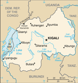
Rwanda contains a total coverage of 26,338 sq km and ranks as the 149th largest country in the world (comparable to the size of Maryland). The total area of Rwanda is derived from 24,668 sq km of land, and 1,670 sq km of water. Rwanda's land boundaries are 893 km, sectioning off the country from Burundi, The Democratic Republic of the Congo, Tanzania, and Uganda. The coastal boundaries cover a total area of 0 km, as it is landlocked. Rwanda has a temperate climate with two rainy seasons (February to April, November to January); mild in mountains with frost and snow possible. The terrain of Rwanda is mostly covered in grassy uplands and hills; relief is mountainous with altitude declining from west to east. The highest point of elevation in Rwanda is Volcan Karisimbi (4,519 m) , and the lowest point is Rusizi River (950 m).
|
